by John Youden - February 14, 2016

The Puerto Vallarta/Riviera Nayarit region is primarily situated around the Bay of Banderas, meaning traveling nearly anywhere means traveling around the bay; meaning there are no short cuts for getting from downtown Vallarta to Punta Mita, or anywhere else. As the region has grown traffic has increased, putting a larger burden on Highway #200, which arrives from Guadalajara to Banderas Bay at La Cruz on the north shore and follows it all the way to Boca de Tomatlán on the south shore. Meaning #200 is often the only route to take getting from one town to the next. So when there is an accident, or problems with one of the bridges going over the Ameca, traffic can come to a standstill and back up.
There are currently three projects in different stages of development to improve traffic flow and at the same time, provide safer and more secure traveling times. The first is the new highway from La Cruz to Punta de Mita, the second a new highway from Jala to Vallarta, and a third is a complete by-pass around Vallarta along the southern shore that would allow pass-through traffic to avoid Vallarta completely.
The highway to Punta Mita is actually the second phase of improvements that started a number of years ago. The first half was completed some years ago but the second phase has been stalled for any number of reasons. Finally, however, it is now close to being finished with the road complete and paving now underway. It is expected to open before the end of this high season. For those that like to visit, or live in Punta de Mita or Litibu, this is a much welcome improvement. The narrow road that led from La Cruz along the coast was extremely windy and narrow, and because of this there were frequent accidents, especially at dusk. This will certainly make the journey north quicker and safer.
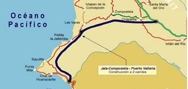
The second highway construction project is a major new highway from Jala to Vallarta, (actually it will be arriving at Bucerias), which most importantly will by-pass the extremely, narrow, winding and dangerous track of highway between Compostela and Las Varas. Portions of this new highway have been in development in stages for years, with the first stage to supposedly be finished sometime this year, with the whole route ready sometime in 2017. As the first stage is already late (they first said 2015), it will probably be in 2018 before we’ll have a better, safer and quicker route to and from Guadalajara.
The total project is projected to cost 11 billion pesos and would shorten the trip from Guadalajara to Vallarta to just over two hours (it is currently about 3.5 - 4 hours). The above image shows the intended route in blue. Below are pictures of some of the construction of four viaducts that needed to be built (for those of you who may not believe - and for good reason - that the road is actually underway).
The third project I've been told has started in behind Vallarta, a Vallarta "periferico." The project involves a by-pass that would allow traffic that is heading south to completely avoid the town, meaning no more huge trucks driving through Vallarta and along the narrow highway that hugs the southern shore of the bay. It would meet up with the new highway mentioned above, continue behind Vallarta in the valley, (meaning another set of bridges over the Ameca River), and on top of the foothills of the Sierra Madre that but up next to the shores of Banderas Bay; going behind Conchas Chinas, Garza Blanca and Sierra del Mar. This would eliminate a lot of heavy traffic and alleviate the current traffic problems that often occur on this route. That's the good news. The bad news is that nothing has been released lately that says when this project may even begin. If anyone out there knows more about it, please share it with us.
Similar posts


